By Debbie Bulloch

A few weeks ago I wrote an article describing the mood of Californians after the Japanese attack on Pearl Harbor and the attack, few months later, on a Santa Barbara offshore oil field. As a result of those two events, the Army decided to install two gun emplacements off the mouth of the Ventura River. You can check the post here:
Sunday Photo History Corner - April 19, 2009.At the time that I posted the April 19 article, I promised that I would go to the actual site of the gun emplacements and take pictures of the remaining ruins and share them here with you.
Well, I do like to keep my promises so this Sunday morning I headed out by bike to the beach where the guns are located and waited for the low tide. When the tide was low enough (at approximately 11:00 a.m. PST – SL time) that I could safely walk across the mouth of the Ventura River, I picked up my bike, held it aloft (cross-country rider style) and headed for the gun emplacements.
After walking for a about half a mile I reached the site of the East Gun. The low tide had exposed both gun sites. Please note, however, how the shore line has shifted by comparing my photographs to
photographs of the same area taken approximately five years ago.
Walking on wet sand, pushing a mountain bike and carrying a backpack with photo gear can pose a special challenge – but it can also provide a nice workout (especially for the calf muscles). When I finally got to the first gun emplacement I encountered one problem that I had not planned for. The rocks around both gun emplacements had been worn smooth by the constant action of the tides and waves. Additionally, the smooth rocks were covered with slimy green seaweed (“sea lettuce”). The combination of smooth rocks and “sea lettuce” made these rocks extremely slippery - too slippery to walk across on my bike shoes. Cleated shoes are great for pedaling (the cleats on the soles attach to the pedals). But the very same thing that makes cleated shoes great for bike riding makes them lousy for walking across wet and slippery surfaces rocks. Some of the rocks were also covered in places by sharp coral-like growth. This growth made the rocks too rough to walk across barefooted – the sharp, cutting edges could cut right through the soles of feet made tender by the water. So, much to my disappointment I had to content myself with taking shots from a safe distance, using a telephoto lens. (I promise, however, that I will return to take more pictures - this time using proper footgear.)
Here are photos, taken from various angles, of the old gun emplacements. The type of gun emplacement used on the shores of Ventura County is called a “Panama Mount.” Here is information on what a
Panama Mount gun emplacement is. Here are photographs of surviving
Panama Mount guns. Please note that on these photographs the “mount” is at the center of the circle and the top is level. I have not found photos of what the Ventura guns looked like when they were first installed. I suspect, however, that the “mount” was also at the center and the top was level (like in the pictures of the Bolsa Chica guns). Time, a shifting coast line (the original Ventura guns were well above the tide line) and the power of the ocean’s waves have shifted the location of the mount shown on my photographs.
A view of the East Gun emplacement. Same gun emplacement, but in black and white.
 A view of the rail upon which the gun turret turned.
 Close up of the gun mount. Please note that the mount is off-center and it is no longer level (like the ones seen in the pictures of the Bolsa Chica guns). Time, the shifting surf line and the powerful action of the waves have taken a toll on the guns of Ventura.
 This is a view "back" to the area behind the guns, the area that the guns were supposed to protect. The city of Ventura is in the background.
 Another view of the East Gun.
 Another view of the East gun emplacement. Please note on the background, on the left hand side of the picture, my trusty "steel steed" at rest.
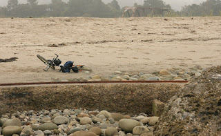 These are two views of the second gun emplacement, the West Gun. I will take closer pictures of this gun at a later time.

As and “added” bonus I have included some photographs that I took of the surrounding area.
A crane scouting the surf. Planning to go surfing perhaps? A sun bleached tree trunk. Black and white.
 Two trees. The train bridge over the Ventura River is to the right of the trees. The bridge is still in use by AMTRAK and by Southern Pacific RR. The bridge was in place before the guns were set up.
 Close up view of bridge.
 Amtrak train going over the same bridge. Picture taken from the East side of the Ventura River.

And as a real “value added” bonus, here are photographs of a dolphin pod that was feeding close to the surf line. The pod probably consisted of a mommy dolphin and its baby (in one photograph you see them swimming very close to each other). In the pod there were also what appeared to be two males dolphins and maybe one or two more females. Dolphin sightings are common along this stretch of the Ventura coast between the shore and the Channel Islands. The area is a protected habitat, the waters are deep and cold and they are full of rich marine life presenting these playful and smart animals with a perfect playground – and an all-you-can eat seafood buffet.
Images of dolphins frolicking by the beach - followed by birds.


 Seaside life in Southern California - kids playing on the beach, surfers, dolphins and a boat. It does not get any better than this (earthquakes or not).
I hope you enjoyed looking at these photographs as much as I enjoyed taking them. (In the summer I may rent a kayak so that I can get closer to the dolphins. But first I need to spend more hours on the rowing machine to build my upper body and I need to buy a waterproof case for my camera gear. Stay tuned!)
BTW – as I was finishing this post another small quake rattled Southern California. Maybe the “Big One” is coming! Here is the preliminary information on this “event.”
A moderate earthquake occurred at 8:39:36 PM (PDT) on Sunday, May 17, 2009.
The magnitude 4.7 event occurred 3 km (2 miles) NNE (24 degrees) of Hawthorne, CA.
The hypocentral depth is 14 km (8 miles). This quake caused moderate damage in the L.A. area, it was followed by a number of aftershocks.
For the latest information, please click the link below.
May 17, 2009, Hawthorne Earthquake
This is the same fault line that caused severe damage in the 1933 Long Beach Earthquake. The extensive damage caused by the 1933 quake eventually led to the enactment of very strict building codes.


